

Spurn Head is a constantly changing spit that reaches out into the Humber like a bent finger. It’s formed from the erosion further up the coast and, whilst once it had a proper road connecting it to the mainland, it is now cut off at high tide and connected by a causeway at other times.
We took the A165 south and then headed along the road from Hull towards Spurn. As we entered one of the villages on the way I remembered that our neighbour who had left the campsite the day before lived there.
“John and Mary live here” I said. As I said this I look to my right. “There’s John!” He was out weeding his garden! So in we went for a cuppa and some stories from John about strange goings on in his garage…! This isn’t the only coincidence we’ve experienced in the last couple of weeks either.
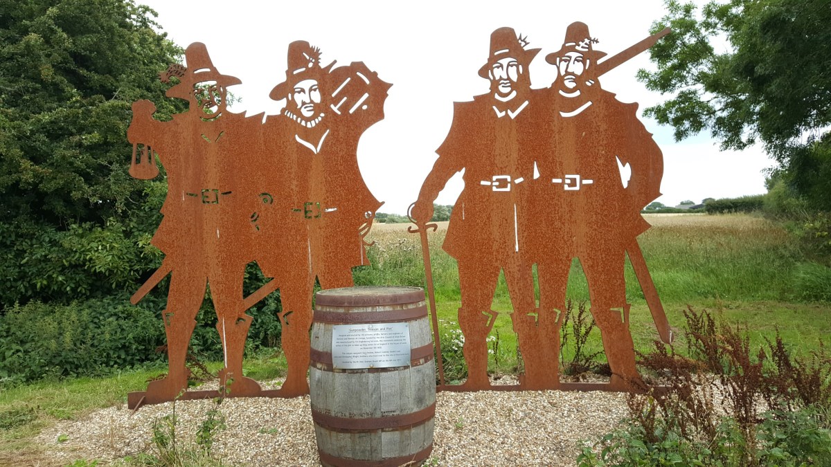
They told us about a couple of things to look out for on our way to Spurn Head, including a stone denoting the meridian line, and the memorial to 2 of the gunpowder plotters who were brothers who lived on a farm in the area. This is done in the same style as the memorial to the airmen at Lisset.


We then visited the church at Patrington, otherwise known as The Queen of Holderness. Chatting to a man inside we found out that the column that looked out of place was, in fact, part of a much earlier church that had been on the site.


Finally we made it to Spurn Head. Or at least we thought we had! We parked just past the café by the toilets and were confused that we couldn’t see anything obvious to suggest we were about to cross a causeway. Well, this was because we weren’t there yet! We should have turned right at the café….
We parked on the road outside the car park, unloaded the bikes and set off. It wasn’t long before we came to sand; sand that you couldn’t cycle over unless you had those special fat tyres. Why we hadn’t realised that the causeway would be sand I really don’t know!
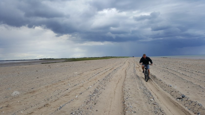
It therefore took a while to cross this 3/4 mile stretch! Luckily we made it to the other side and the 1st shelter before the heavens opened! The shelter was just big enough to fit 4 people in ‘cosily’. There were just the 2 of us so that meant that Calv was able to bring his bike in too…. It was great fun sharing that space for about 20 minutes!


Luckily the one couple who passed by were so soaked already that they decided to just continue. Once you’ve got past the last bit of sand (and the bit of the path that’s fallen into the sea) the path isn’t bad at all (although we had an awful lot of big puddles after the rainstorms we were dealing with!)


There are several nature trails to follow along the spit, a lighthouse that is open at certain times and the RNLI station. This is also where the river pilots operate from.
You cannot drive onto Spurn Head. However, you can book onto a Spurn Safari, ride your bike or walk. The authorised vehicles use the same narrow paths as walkers and cyclists so be aware!
The total cycle from the car park is 3.5 miles. On the way back the sun came out for us and we were delighted to spot a number of seals bobbing their heads out of the water close to the shore. And then we had a rainbow 🙂


Being late home we eventually realised that we were going to have to eat on the way. We followed the coast road back and driving through Aldbrough we spotted a fish and chip shop that had a café – The Frying Farmer. What a find – the best fish and chips we have ever had. And I had a slice of gorgeous Victoria sponge to take away!
Despite the weather we had a wonderful day out when we visited Spurn Head and would highly recommend it – don’t forget to check the tides, but there is plenty of information available when you get there 🙂
